

карта Galicia and Bukovina are two adjacent regions, located on the northern slopes of the Carpathian Mountains. Today the area is divided between independent Ukraine, Poland and Romania.
The name Galicia is derived from “Halicz,” the name of a town which was the center of the medieval Halych-Volynian principality, initially a part of Kievan Rus'. In the 1340s, the largest part of the Halych principality was a part of the Polish Kingdom. In 1772, after the first partition of the Polish-Lithuanian Commonwealth, Galicia was annexed from Poland and became Austrian Crown land, under the name "The Kingdom of Galicia and Lodomeria." The area of Malopolska, around Krakow, was incorporated into Austria as a result of the third partition of Poland, but was then transferred to the Napoleonic Duchy of Warsaw in 1809. At the Congress of Vienna in 1815, the town of Krakow and a small surrounding area was made an independent republic under the protection of the three partitioning powers (Austria, Prussia and Russia). Following the outbreak of revolution in 1846, the area was annexed by Austria and incorporated into Galicia.
In 1918, Galicia was reclaimed by the independent Polish Republic, although a short-lived Western-Ukrainian People's Republic existed in Eastern Galicia in 1918-19. In 1939, Eastern Galicia was annexed by the Soviet Union and became a part of Soviet Ukraine. Since 1991 this area has belonged to the Independent Republic of Ukraine.
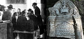
The rivers San, Dniester, Seret and Prut flow through the region. The capital of the area is Lviv (Lemberg, Lwόw). Other major cities are Brody and Tarnopol in the west, Ivano-Frankivsk (Stanislawow) in the south and Krakow in Western Galicia. The Jewish population in the area grew rapidly over the long 19th century, from 178,000 in 1772 to 811,000 in 1900.
Bukovina is a historical region on the northern slopes of the Carpathians and is currently divided between Romania and Ukraine. It is first mentioned in 1388 as part of the Principality of Moldavia. Bukovina’s name is derived from the Ukrainian word for 'Beech tree,' a plant distinct in the landscape of the region. Bukovina was occupied by the Austrian Empire in 1774, and in 1787 was incorporated into "The Kingdom of Galicia and Lodomeria." In 1849 it became a separate Austrian 'Crown Land' – the Duchy of Bukovina, with Czernowitz (now Chernovtsy) as its capital. After World War I Romania took control of the region. In 1940, the northern half of Bukovina was annexed by the Soviet Union. Today, Northern Bukovina is a part of Ukraine and Southern Bukovina is a part of Romania.
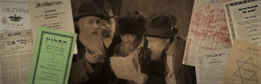
Jews have lived in Bukovina since the 14th Century. During World War II most of Bukovina’s Jews were deported to Transnistria and many did not return.
The Geo-Political history of Galicia and Bukovina has left us with many maps of the area in many different languages, the wide variety of which demonstrates different methods of map-making. The earliest maps of the region we were able to obtain go back as far as the 14th century.. Some of the maps in the database depict the entire region, while others focus on smaller areas and cities.